Better Planning for Landscape Photography.

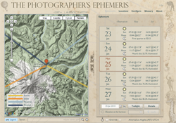 Planning just the right time and location for landscape photography can be challenging. Landscape photographers typically want to plan their shoots around the times of sunrise/sunset or twilight.
That’s why photographer Stephen Trainor created the Photographer’s Ephemeris, an Adobe AIR application that provides a visual and simplified solution for finding vantage points for dusk and sunset photography. It integrates satellite and terrain maps from Google into a visually pleasing interface.
Link: The Photographer’s Ephemeris App
Read on for a couple video tutorials showing this tool in action.
Photographer’s Ephemeris: Video Tutorials
Two video tutorials from Yellow Wood Guiding on the use of The Photographer’s Ephemeris software:
Source: This tip is loosely inspired by a discussion last week with nature and wildlife photographer Jon Cornforth during the live recording session of the John Greengo Photography Show. You can subscribe in iTunes to be among the first to get a copy of that interview when we post it later this week.
Not sure your Macs are ready for what’s next?
Book a free, no-pressure call. We’ll review your fleet, flag what needs attention, and you’ll leave with a plan either way.
Let’s Talk →Apple news worth your inbox.
One monthly note on the updates that actually affect your workplace. No noise.
Keep reading

Coming Soon: Most Pantone Color Books for Adobe Creative Cloud to Require Pantone Connect License

Find Wasted Space with Storage Management